


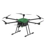
XTF1200 Hexa-Rotor UAV
XTF Series Hexa-Rotor Medium UAV
The XTF Series Hexa-Rotor Medium UAV features moderate size, stronger power, higher stability, and ease of operation.
It has low requirements for combat environments, low cost, a simple structure, and strong survivability.
It can also be used as an unmanned target drone and is compatible with various payload equipment developed by our company.
Suitable for a wide range of applications including fire rescue, military reconnaissance and strike, police security, forest fire fighting, urban law enforcement and inspection, it can meet diverse customer needs.
Contact Us for Pricing
Interested in this product? Contact us now for detailed pricing and product information.
Product Details
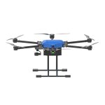
XTF Series Hexa-Rotor Medium UAV
The XTF Series Hexa-Rotor Medium UAV features moderate size, stronger power, higher stability, and ease of operation.
It has low requirements for combat environments, low cost, a simple structure, and strong survivability.
It can also be used as an unmanned target drone and is compatible with various payload equipment developed by our company.
Suitable for a wide range of applications including fire rescue, military reconnaissance and strike, police security, forest fire fighting, urban law enforcement and inspection, it can meet diverse customer needs.
XTF1200 Hexa-Rotor Medium UAV
| Aircraft Dimensions | 1380×1190×620mm |
| Folded Dimensions | 500×440×620mm |
| Wheelbase | 1300mm |
| Material | Aviation Aluminum Alloy, Carbon Fiber |
| Aircraft Weight | 8kg |
| Maximum Take-off Weight | 24kg (near sea level) |
| Maximum Payload | 10kg |
| Maximum Climb Speed | 5m/s |
| Maximum Descent Speed | 5m/s |
| Maximum Wind Resistance | Level 7 |
| Maximum Flight Altitude | 5000m |
| Maximum Flight Speed | 20m/s (no wind) |
| Maximum Flight Time | 30–70 minutes |
| Maximum Control Range | 10km (open, unobstructed, no electromagnetic interference) |
| Maximum Flight Climb Height | 1000m |
| Hover Accuracy | Vertical: ±0.5m Horizontal: ±1m (with normal GPS positioning) |
| Satellite Positioning Module | GPS/GLONASS/BDS/Galileo |
| Camera | 4K HD, 10x/30x optical zoom |
| Power System | Integrated FOC Power System |
| Operating Temperature | -30℃ ~ 60℃ |
| Waterproof Rating | Can be washed with water; resistant to moderate rain |
| Battery Capacity | 30000mAh |
Handheld Ground Station
| Operating Frequency | 2.4GHz & 5.8GHz Dual-band |
| Main Control Chip | Pangu S1 |
| Operating System | Android |
| Effective Signal Range | Approx. 10km (open, unobstructed, no electromagnetic interference) |
| Video Output Interface | HDMI / WLAN |
| Built-in Battery | 7.4V 20000mAh LiPo 2S |
| Battery Life | 20 Hours |
| Display Screen | 7-inch, 1920×1200 resolution |
| Maximum Brightness | 2000cd/㎡ |
| Memory Card Type | MicroSD, up to 128GB |
| Three-position Switches | No less than 4 |
| 2D Joysticks | Supported |
| Protection Rating | IP54 |
| Integrated Operation Interface | Integrated flight data, switchable between image and map |
| Voice Broadcast | Adjustable real-time voice broadcast |


